Early East Melbourne
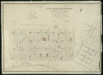
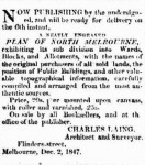
1847 Plan of North Melbourne by Charles Laing
The map shows the city of Melbourne with names of orginal purchasers marked. Public buildings are also marked. The western edge of the proposed East Melbourne is shown with streets marked with a set of names very different from the eventual names used.
The map is in the collection of the State Library of Victoria and its citation is below:
- 2663 reads
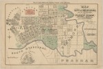
1852 Map of the City of Melbourne and its Extension - William Green
A map issued by O'Connor & Co., Land Agents. It is a copy of the original map drawn by William Green, surveyor, architect and land agent, in 1852 and released in December that year. The map covers the City of Melbourne and inner suburbs. It probably dates from the 1920s as by the 1930s PJ O'Connor had begun practising as an architect.
- 3452 reads
1857 Design for Fitzroy Square by E L Bateman
A plan showing the proposed design for the laying out of the Fitzroy Gardens by Edward La Trobe Bateman. The plan was commissioned by the City of Melbourne. The Age of 1 Jun 1858 reported on a Council meeting the previous day in which it was agreed, after some debate, to pay Bateman £100 for his work, which also included a plan for the Carlton Gardens.
- 2271 reads


