Maps
Map of East Melbourne 1858
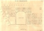
Map of East Melbourne based on 1850 survey by C.C. Horrel. Scale 4 chains to the inch. Published by the Public Lands Office Melbourne in 1858. Lithograph by J.B.Philp and W. Hollis.
Properties and owners are marked.
- 4540 reads
Map of East Melbourne 1864-1879
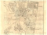
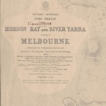
Partial print of the so called "Cox Chart" 1864. "Hobson Bay and River Yarra Leading to Melbourne" by Commander H.L. Cox R.N. 1864 with updates in 1875 and 1879.
- 8643 reads
The Zoological Gardens 1858

The proposed plan for the Zoological Gardens which was to be established in the southern-most part of the Richmond Paddock, now roughly the site of AAMI park.
- 2383 reads
Typhoid Fever connected with milk-supply
A paper given at the Intercolonial Medical Congress of Australasia. A study of an outbreak of typhoid which spread from a dairy in Jolimont in 1879. Descriptions of Jolimont include rubbish tips, sewage, drainage. Detailed description of the house and dairy, and day to day procedure. The dairy appears to be 157 Wellington Pde. Sth. Maps. Tables.
- 4553 reads