Home

East Melbourne Historical Society

Drop-down menu

  • Articles
  • People
    • Notable Women
    • WW1 soldiers and nurses
    • WW1 nurses
  • History
    • Milestones
    • Buildings
    • Community
    • People
  • Gallery
    • Maps
    • MMBW plans
    • Abortion battles
    • Bishopscourt
    • Bishopscourt garden
    • Bomb shelter
    • Buildings
    • Cairns Memorial Church
    • Early Melbourne
    • Football
    • Jean Campbell
    • Lanes
    • Margaret McLean
      • Family and home
      • Female suffrage
      • Clippings - Australia
      • Clippings - Britain
      • Clippings - USA
    • Personalities
    • Yarra Park
      • History
      • Desecration
    • Yarra River
  • Catalogue
    • Browse and Search
    • Catalogue table view
    • Site images
  • Images
  • Society
    • Activities
    • Newsletters
    • Tributes
      • John Barrie Wykes
      • Wynne McGrath
    • Publications
      • Heritage Matters
      • What's in a Name
    • About
Home
    • Home
    • Search
    • Forum
    • Contact

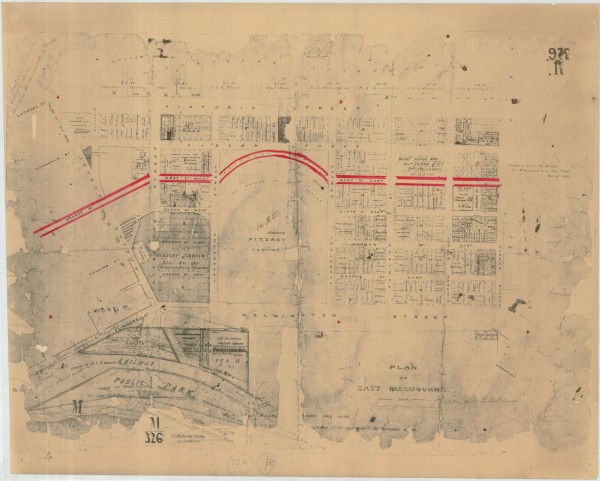
1850 East Melbourne Plan with later amendments

  • first
  • ‹ previous
  • 1299 of 2366
  • next ›
  • last
Image
Move your mouse over image or click to enlarge
Acquisition number: 
810
Catalogue number: 
eml0005
File name: 
EML0005
File location: 
East Melbourne Library

Plan of East Melbourne labelled 1850 but with various amendments dated 1862, 1863, 1864 and 1865
Significantly reworked from the 1848 plan.
Includes:
An extension of Bourke Street cutting through what was previously shown as the Legislative Assembly building to join up with Gisbourne Street, crossing into Grey Street West which would then continue in a curve through the top of Fitzroy Square and curve back to join Grey Street East;
Gisbourne Street terminates at Carpentaria Place and Gipps Street East making way for Treasury Gardens;
Eades Street is the new name for what was Singleton Street in 1848;
Darling Square is identified and a Volunteer Parade and Recreation Ground is shown in the location of what is now Powlett Reserve;
A State School is now shown on the south west corner of Wellington Street and Hoddle Street;
Allotment numbers and some names.

Item type: 
Map
Item size: 
42x34 cm
Item condition: 
Poor
Date digitised: 
2009-11-18
  • 4062 reads
  • Share this
  • PrintPrint
  • EmailEmail

User login

  • Join EMHS
  • Request new password
  • Privacy
  • Membership
  • About
  • Contact
  • Guidelines