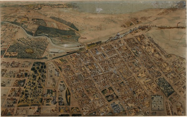
Melbourne and Suburbs Isometrical Plan - 1866
- first
- ‹ previous
- 1333 of 2410
- next ›
- last
A very detailed coloured lithograph by De Gruchy and Leigh of an aerial view of Melbourne in 1866 looking south from a point approximately above the corner of Victoria and Spring Streets. The picture extends from Yarra Park in the east to Batman's Hill in the west and from Albert and Lonsdale Streets in the north to Port Philip Bay in the south.
Brass plaque on the bottom of the frame:
Melbourne and Suburbs
Isometrical Plan
1866
De Gruchy and Leigh
La Trobe Picture Collection
State Library of Victoria
Framed picture purchased from the the State Library of Victoria circa 2005.
Digital image obtained from the State Library of Victoria.
State Library record:
Title: Isometrical plan of Melbourne & suburbs, 1866
Author/Creator: De Gruchy & Leigh
Date(s): 1866
Description: 1 print : lithograph with hand colouring ; 59 x 93 cm., in frame 83 x 113 cm.
Copyright status: This work is out of copyright
Identifier(s): Accession no(s) H291
Subjects: Melbourne (Vic.) -- Pictorial works ; Bird's-eye view prints ; Lithographs
Index terms: Melbourne; Victoria; Australia; bird's-eye views
Notes: Frame: wood.
Black and white photographic copies H23932, H29613.
Title and date from plaque on frame l.c.
Lithographers name on plaque on frame: DE GRUCHY & LEIGH
Key to plan at H6091.
Contents/Summary: Shows the layout of Melbourne streets with buildings, the Yarra, Port Phillip Bay in distance, parts of Collingwood and East Melbourne.
Link to digitised item: http://handle.slv.vic.gov.au/10381/50617
Link to this record: http://search.slv.vic.gov.au/primo_library/libweb/action/dlDisplay.do?vi...

